How Wudang Mountain’s Temples Form One Imperial Route
武当山宫观总体布局:一条皇家朝山路线
The most useful single idea for understanding Wudang is that it is a road with buildings on it, rather than a site that happens to have a road running through it. Once you hold that, the distribution of the complexes stops looking arbitrary and starts looking like an argument.
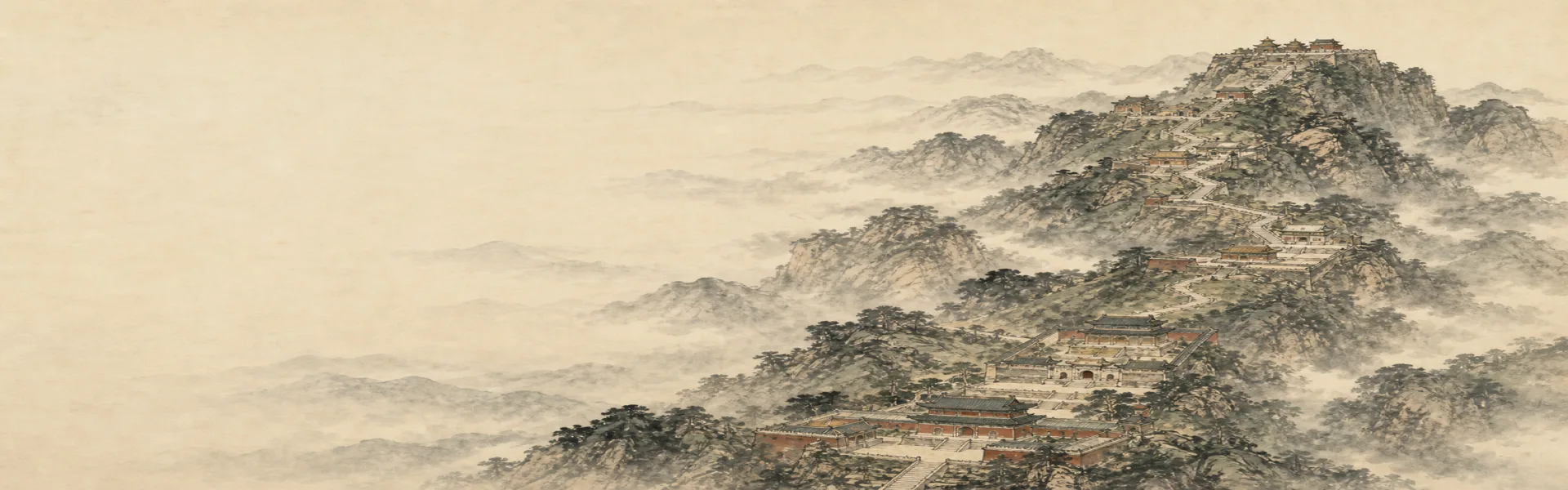
One road, everything on it
A conventional Chinese temple is a walled compound on flat ground, entered at one end, with a straight axis running through a series of courtyards to the principal hall. The compound is the unit of design, and the road outside it is merely how you arrive.
At Wudang the road is the unit of design. The ascent from the foot of the range to the summit is the axis, and the palaces, temples, hermitages and cliff shrines are disposed along it. There is no wall around the whole, because the whole is a route rather than an enclosure. Individual complexes have their own walls and their own internal axes, but they function as stations on a longer line, in the way that courtyards function as stations within a single temple.
This is why the site cannot be understood from a plan of any one complex, and why photographs of individual halls miss the point. The designed object is the sequence, and the sequence is several kilometres long and more than a thousand metres high.
Fit the buildings to the mountain
The rule the builders followed can be stated in one sentence: adapt the architecture to the terrain rather than the terrain to the architecture.
In the imperial capital the opposite rule applied. Ground was levelled, axes were laid out true, symmetry was absolute, and the landscape was subordinated to the plan. That is what state power looks like when it is building on a plain. On this mountain the same government, in the same reign, did the reverse: it terraced instead of levelling, bent complexes to follow ledges, stacked courtyards up slopes, made buildings narrow where the ground was narrow, and accepted asymmetry where symmetry was impossible.
It is worth asking why, because the Ming state could certainly have moved more earth. Part of the answer is cost, but part of it is doctrinal. The mountain was itself the object of reverence and the residence of the deity; flattening it to accommodate a hall would have destroyed the thing the hall was there to honour. Chinese siting practice also held that a building gains from a correct relationship with landform, which cannot be manufactured on a bulldozed platform. So the adaptation was not merely practical humility. It was a statement that the mountain outranked the architecture.
The sequence
The order of sites along the road is the substance of the plan, and it does two things simultaneously.
Architecturally it grades the ascent, so that scale, elaboration and rank rise and fall in a controlled way as you climb, with major complexes spaced by lesser ones and by stretches of stairway that give the eye a rest and the legs work to do. Narratively it follows the life of Zhenwu: the site of his near-abandonment low down, the complex of his princely origins above it, the great mid-mountain palace of his long cultivation, the cliff of his ascent, and the summit where he is enthroned as a god.
So the climb is a biography told in buildings, and arrival at the summit is arrival at the end of a process rather than merely at the top of a hill. The plan does not simply organise a visit; it argues that transformation requires a long effort, and it makes you perform that argument with your legs.
Gates, thresholds and the staging of arrival
On flat ground, courtyard walls and gates control how a building is revealed. On a mountain the same job is done by gateways placed along the road, by bends in the path, and by walls that conceal what is ahead.
Freestanding gateways punctuate the ascent, marking thresholds at points where nothing physically obstructs you. Their function is to divide the climb into stages and to announce that you are entering a more significant zone. Approach walls that curve, of which the celebrated undulating wall at the princely slope complex is the best example, prevent you from seeing your destination and reveal it only in instalments. Flights of steps slow you at the moments the designers wanted you slowed, and terraces lift you so that a hall is seen from below.
All of this is the ordinary grammar of the Chinese courtyard sequence, transposed from the horizontal to the vertical. Recognising the transposition is the single most useful analytical move available to a visitor here.
The scale is inverted
Visitors expect importance to increase with height, and at Wudang it does not, which confuses people until it is explained.
The largest complex of the entire programme sits at the foot of the range, and the building at the very summit is a bronze hall a few metres across. That looks backwards until you separate two different kinds of importance. Ritually, the summit is the culmination: it is where the deity is enthroned, and it is deliberately small, singular and hard to reach. Administratively, the foot is the centre: it is where pilgrims arrive, clergy are registered, supplies are received, officials are housed and records are kept, and all of that requires floor area.
The inversion is therefore not a design error but a correct expression of two truths at once. The most sacred point is a small object at the end of a long climb. The institution that maintains it is a walled town at the bottom. Any large religious organisation has the same shape, and Wudang simply makes it visible in stone.
What the plan gave up
An honest account of a design should say what it sacrificed, and this one sacrificed a good deal.
Symmetry went first, at least at the level of the whole; individual complexes are as symmetrical as their sites permit, but the overall composition is a line that bends. Spaciousness went too: courtyards on the ascent are small compared with those of flat-site temples of equivalent rank, because level ground had to be bought with retaining walls. Convenience was abandoned entirely, since the plan requires an ascent of over a thousand metres to complete. And maintainability was compromised, because buildings on ledges, cliffs and steep slopes are far harder to repair, resupply and protect from fire than buildings on a plain.
Those sacrifices are the reason the site is impressive and also the reason so much of it has been lost. The plan optimised for meaning at the expense of durability, and the history of the mountain is largely the bill for that choice.
What the plan was for
Three purposes at once, and they reinforce each other.
It was a religious instrument, designed to make a pilgrim's ascent enact the biography of the deity and to place the moment of arrival after a genuine effort. It was a political statement, demonstrating on a scale impossible to overlook that the dynasty's patron god had been honoured by an emperor who needed Heaven's visible approval. And it was an administrative system, a working institution with a headquarters, supply routes, staff and accounts, distributed across a difficult landscape and required to function daily.
Most descriptions of Wudang pick one of these and drop the others. Holding all three at once is what makes the place legible.
Reading the plan on the ground today
The modern visitor operation overlays the historic plan without replacing it, so some deliberate effort is needed to see through one to the other.
Traffic is funnelled from a controlled entrance, part of the ascent is covered by vehicle, and a cable car spans a section of the upper mountain. That means the staging the designers built is partly bypassed: you can arrive high on the mountain without having climbed to it, which removes exactly the effort the plan depended on. The counter-measure is simple. Walk at least one connected stretch of the historic stairway, in ascending direction, passing through its gateways in order. Even a single section restores the experience the plan was built to produce.
Beyond that, look for the plan's own devices: notice gateways where there is no wall, look back down through courtyards as well as up, register how a curving approach withholds a view, and read rank from roof form and platform height before you read any sign. And keep the inversion in mind, so that the enormous ruin at the bottom and the small bronze hall at the top both make sense.
Sources and limits. The account of the site's planning follows standard scholarship on Chinese architectural and landscape planning and on this site, together with the mountain's gazetteers and published conservation material. The narrative reading of the ascent is well attested, though the date at which individual site associations became fixed is not always determinable. Comparisons with capital planning are general. Transport stages and access arrangements change and none are stated here.
Key points
Wudang is a road with buildings on it, not a site with a road through it, and the designed object is the whole sequence.
The builders adapted architecture to terrain, the reverse of practice in the capital, because the mountain outranked the buildings.
The sequence grades the ascent architecturally and narrates Zhenwu's life, so the climb is a biography told in buildings.
Gateways, curving approach walls, flights of steps and terraces transpose the courtyard grammar from horizontal to vertical.
Scale is inverted: the administrative centre at the foot is the largest complex, the ritual summit a hall a few metres across.
The plan sacrificed symmetry, spaciousness, convenience and maintainability, which is why it impresses and why much was lost.
It served three purposes at once — religious instrument, political statement and working administration.
Modern transport bypasses part of the staging, so walking one connected stretch of historic stairway restores the intended experience.